Services – Integrated Solutions
Hydrosat
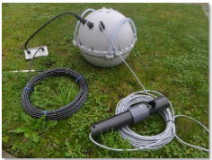
ARGOS HydroSat is a complete hardware & service package that includes a robust and cost efficient buoy for monitoring rivers and lakes, Argos airtime and tailored data processing services with visualization via our website.

Measure water level

Measure flow

Monitor flooding and surges

Identify salt water intrusions

Improve knowledge about inland water systems
Hardware
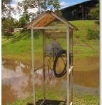
The HydroSat station uses the Argos satellite telemetry system to automatically transfer physical properties of inland waterbodies (water-level, conductivity, flow…) from anywhere in the world. It is especially designed to function in harsh environments
Key features
Data & Airtime
Basic Service:
The basic Argos service for HydroSat includes:
- Data transmission
- Data decoding at CLS ARGOS Data processing Centre (monitored 24/7, with 2 redundant centers)
- Secure access to ArgosWeb portal to view & export data (csv, tab, etc.)
- Webservices access if needed to interface existing software with our database (development required by the end-used)
Extra HydroSat Services:
Bit errors in satellite transmissions occur frequently in areas with complex environmental settings (i.e. important vegetation, humidity, etc.). ARGOS Smart Data Filtering filters out outliers from Argos observations in a smart fashion, and keeps correct measurements in messages that can contain bit errors.
It is therefore adapted to operational monitoring of environmental parameters, such as water level, conductivity, etc. This service is currently used by the French office for Hydrological Monitoring in French Guyana (20 stations currently deployed).
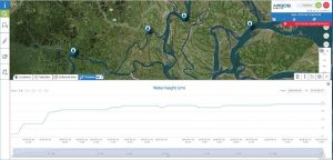
This service adds to ArgosWeb the option to plot real-time HydroSat data. It is possible to customize visualizations , based on the specific requirement of end-users (type of data, scales, refresh rates, etc.). Get in touch with us to know more about it.
Value-added visualization service for HydroSat data (click to enlarge)


